
Precision in Every Pixel: Mapping & Surveying
Update your aerial photogrammetry with the Yuneec solutions, which are made for surveyors and geospatial professional
- Our payloads promise accuracy and precision, capturing high-quality data from above with crystal-clear images and remarkable detail.
- Tailored for mapping, surveying, city projects, architecture, and monument protection - a great solution to capture aerial data.

Oblique Camera
Take pictures from five different angles in one single flight only.
With 125 million pixels, the Oblique Camera redefines high resolution in aerial imaging.
- Flight Accuracy: 3 cm flight accuracy, ensuring pinpoint precision in every aerial endeavour.
- Elevation Accuracy: 5 cm elevation accuracy, delivering reliable and detailed topographic data.
- Impressive Airspeed: Navigate through projects seamlessly with an airspeed of 10m/s, enhancing efficiency in data acquisition
Ready to transform Your Aerial Surveying?
Get it now!
E45S
Your essential tool for mapping and surveying!
The camera redefines high resolution in aerial imaging with the 45MP full frame sensor.
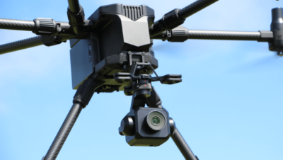
- High Precision: The E45S ensures accuracy through a full-frame sensor that delivers the highly detailed images.
- Distortion-Free Imagery: With its 3-axis stabilized gimbal, the E45S guarantees distortion-free shots, providing you with imagery that is sharp and perfectly aligned.
- Many Application Options: Whether overseeing a construction site, conducting land surveys, analyzing environmental data, or inspecting structures like building facades or wind turbines, the E45S is your trusted companion for accurate and reliable data.
Ready to improve your aerial efforts with Yuneec's E45S?
Get it now!
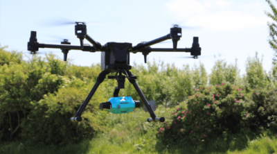
LiDAR GS100
Whether you are navigating the complex landscape of agriculture, executing land planning, surveying a digital urban construction, or ensuring the reliability of electricity infrastructure, the LiDAR GS-100C is developed to capture the required data for your 3D model projects.
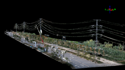
- Remarkable Measurement Accuracy: the GS-100C boasts a measurement accuracy of ≤10cm at an impressive range of 110m.
- High-Speed Scanning: Operating at a rate of 720,000 points per second, the GS-100C captures an extensive dataset with Triple Echo technology, guaranteeing meticulous details and rich data for analysis.
- Panoramic View: Boasting a 70° panoramic view, the GS-100C captures a wide field of vision, making it ideal for land planning and digital urban construction applications.
Ready for your point cloud?
Get it now!
Discover our solutions and get results like never before with the Yuneec system and accompanying payloads – your gateway to accurate and reliable aerial data.

Would you like to Transform Your Aerial Surveying Experience? To explore the possibilities
Contact US today!
This site is registered on wpml.org as a development site. Switch to a production site key to remove this banner.